
Process groups keep related terrain derivatives together so interpretation does not rest on a single high-ranking variable. The labels are terrain-form categories. They organize surface form for summaries and models; they are not direct measurements of currents, sediment flux, habitat condition, or ecological processes.
The catalog follows the process names used in the manuscript:
seafloor aspect, slope gradient, accumulation potential, transport
potential, seafloor position, seafloor rugosity, downslope pathway
proximity, and curvature. Accumulation potential replaces the older
terrain-convergence wording. External layers named
wetness_index_wbt, convergence_slope_index, or
convergence_slope_index_wbt are assigned to
accumulation_potential.
Metric Catalog
catalog <- metric_catalog()
catalog[, c("metric", "label", "process_group", "scale_sensitive")]
#> # A tibble: 50 × 4
#>    metric     label      process_group   scale_sensitive
#>    <chr>      <chr>      <chr>           <lgl>
#>  1 bathy      Bathymetry base_bathymetry TRUE
#>  2 hillshade  Hillshade  base_bathymetry TRUE
#>  3 aspect_deg Aspect     seafloor_aspect TRUE
#>  4 aspect_rad Aspect     seafloor_aspect TRUE
#>  5 northness  Northness  seafloor_aspect TRUE
#>  6 eastness   Eastness   seafloor_aspect TRUE
#>  7 aspect_cos Northness  seafloor_aspect TRUE
#>  8 aspect_sin Eastness   seafloor_aspect TRUE
#>  9 slope_deg  Slope      slope_gradient  TRUE
#> 10 slope_rad  Slope      slope_gradient  TRUE
#> # ℹ 40 more rows
The catalog records the source function, units, and interpretation notes for the exported terrain metrics.
Assigning Groups
bathy <- read_bathy(blueterra_example("hitw"))
prepared <- prepare_bathy(bathy, depth_range = c(-220, -25), smooth = TRUE)
terrain <- derive_terrain(
  prepared,
  metrics = c("slope", "aspect", "northness", "eastness", "tri", "bpi",
              "curvature", "surface_area_ratio")
)

assign_process_groups(terrain)
#> # A tibble: 9 × 7
#>   metric metric_standard label process_group description source_function matched
#>   <chr>  <chr>           <chr> <chr>         <chr>       <chr>           <lgl>
#> 1 slope… slope_deg       Slope slope_gradie… Local stee… derive_slope    TRUE
#> 2 aspec… aspect_deg      Aspe… seafloor_asp… Local down… derive_aspect   TRUE
#> 3 north… northness       Nort… seafloor_asp… Cosine tra… derive_northne… TRUE
#> 4 eastn… eastness        East… seafloor_asp… Sine trans… derive_eastness TRUE
#> 5 tri    tri             Terr… seafloor_rug… terra terr… derive_tri      TRUE
#> 6 bpi_3… bpi_3x3         Fine… seafloor_pos… Fine-scale… derive_bpi      TRUE
#> 7 bpi_1… bpi_11x11       Broa… seafloor_pos… Broad-scal… derive_bpi      TRUE
#> 8 curva… curvature       Four… curvature     Sum of the… derive_curvatu… TRUE
#> 9 surfa… surface_area_r… Surf… seafloor_rug… Slope-seca… derive_surface… TRUE
summarize_process_groups(terrain)
#> # A tibble: 5 × 3
#>   process_group     n_metrics metrics
#>   <chr>                 <int> <chr>
#> 1 curvature                 1 curvature
#> 2 seafloor_aspect           3 aspect_deg, northness, eastness
#> 3 seafloor_position         2 bpi_3x3, bpi_11x11
#> 4 seafloor_rugosity         2 tri, surface_area_ratio
#> 5 slope_gradient            1 slope_deg
The assignment is based on layer names.
standardize_metric_names() is useful when metric names come
from external rasters or older project files.
standardize_metric_names(c("Slope degrees", "Broad BPI", "Curvature index"))
#> [1] "slope_degrees"   "broad_bpi"       "curvature_index"
rename_metric_layers(c("slope_old", "curv_old"), c(slope_old = "slope_deg"))
#> [1] "slope_deg" "curv_old"
Representatives
Representative metrics are starting points for compact reporting. The final choice should still follow raster resolution, sampling design, collinearity, and the feature scale of the analysis.
select_process_representatives(metrics_available = names(terrain))
#> # A tibble: 5 × 9
#>   metric     label               process_group description units source_function
#>   <chr>      <chr>               <chr>         <chr>       <chr> <chr>
#> 1 curvature  Four-neighbor Lapl… curvature     Sum of the… inpu… derive_curvatu…
#> 2 aspect_deg Aspect              seafloor_asp… Local down… degr… derive_aspect
#> 3 bpi_3x3    Fine-scale BPI      seafloor_pos… Fine-scale… inpu… derive_bpi
#> 4 tri        Terrain Ruggedness… seafloor_rug… terra terr… inpu… derive_tri
#> 5 slope_deg  Slope               slope_gradie… Local stee… degr… derive_slope
#> # ℹ 3 more variables: requires_optional_dependency <lgl>,
#> #   scale_sensitive <lgl>, interpretation_notes <chr>
select_process_representatives(
  representatives = c(seafloor_aspect = "northness", slope_gradient = "slope_deg")
)
#> # A tibble: 9 × 9
#>   metric                   label process_group description units source_function
#>   <chr>                    <chr> <chr>         <chr>       <chr> <chr>
#> 1 flowacc                  Conv… accumulation… Terrain-de… index external
#> 2 bathy                    Bath… base_bathyme… Input bath… inpu… as_bathy
#> 3 curvature                Four… curvature     Sum of the… inpu… derive_curvatu…
#> 4 downslope_distance_to_s… Down… downslope_pa… Modeled do… map … external
#> 5 tpi                      Topo… seafloor_pos… Cell posit… inpu… derive_tpi
#> 6 roughness                Roug… seafloor_rug… Difference… inpu… derive_roughne…
#> 7 stream_power_index_wbt   Terr… transport_po… Compound t… index external
#> 8 northness                Nort… seafloor_asp… Cosine tra… unit… derive_northne…
#> 9 slope_deg                Slope slope_gradie… Local stee… degr… derive_slope
#> # ℹ 3 more variables: requires_optional_dependency <lgl>,
#> #   scale_sensitive <lgl>, interpretation_notes <chr>
cells <- sample_terrain_cells(
  terrain[[c("slope_deg", "tri", "bpi_3x3", "curvature")]],
  size = 50,
  method = "regular"
)
pca <- terrain_pca(cells, vars = c("slope_deg", "tri", "bpi_3x3", "curvature"))
pca_axis_labels(pca)
#>                               PC1                               PC2
#> "PC1 (77.9%; bpi_3x3, slope_deg)"     "PC2 (20.6%; tri, curvature)"
plot_process_pca(pca, title = "Terrain PCA with Dominant Loading Labels")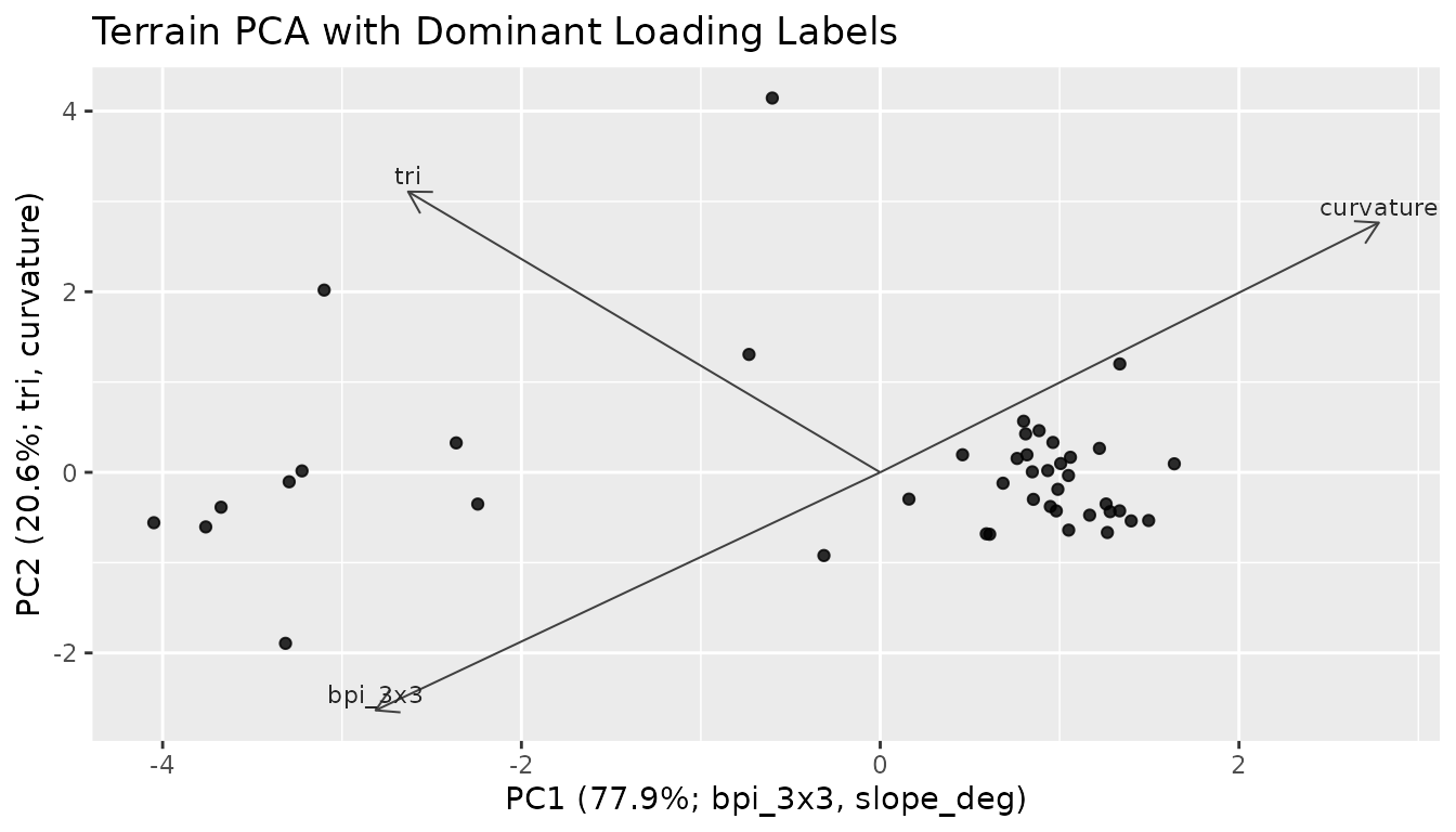
Custom Metrics
Custom metrics can be added to a stack when they share the same grid, CRS, and extent. Catalog rows then place those layers into process groups for summaries and model-ready tables.
slope_tri <- derive_custom_metric(
  terrain,
  name = "slope_tri_index",
  expression = quote(slope_deg * tri)
)

extended <- add_metric_layers(terrain, slope_tri)

custom_catalog <- extend_metric_catalog(
  metric_catalog(),
  create_metric_catalog(
    metric = "slope_tri_index",
    label = "Slope-TRI index",
    process_group = "custom_relief",
    description = "Product of local slope and terrain ruggedness index.",
    units = "index",
    source_function = "derive_custom_metric",
    interpretation_notes = "Example index; define custom metrics from an explicit process model."
  )
)

assign_process_groups(extended, catalog = custom_catalog)
#> # A tibble: 10 × 7
#>    metric        metric_standard label process_group description source_function
#>    <chr>         <chr>           <chr> <chr>         <chr>       <chr>
#>  1 slope_deg     slope_deg       Slope slope_gradie… Local stee… derive_slope
#>  2 aspect_deg    aspect_deg      Aspe… seafloor_asp… Local down… derive_aspect
#>  3 northness     northness       Nort… seafloor_asp… Cosine tra… derive_northne…
#>  4 eastness      eastness        East… seafloor_asp… Sine trans… derive_eastness
#>  5 tri           tri             Terr… seafloor_rug… terra terr… derive_tri
#>  6 bpi_3x3       bpi_3x3         Fine… seafloor_pos… Fine-scale… derive_bpi
#>  7 bpi_11x11     bpi_11x11       Broa… seafloor_pos… Broad-scal… derive_bpi
#>  8 curvature     curvature       Four… curvature     Sum of the… derive_curvatu…
#>  9 surface_area… surface_area_r… Surf… seafloor_rug… Slope-seca… derive_surface…
#> 10 slope_tri_in… slope_tri_index Slop… custom_relief Product of… derive_custom_…
#> # ℹ 1 more variable: matched <lgl>
summarize_process_groups(extended, catalog = custom_catalog)
#> # A tibble: 6 × 3
#>   process_group     n_metrics metrics
#>   <chr>                 <int> <chr>
#> 1 curvature                 1 curvature
#> 2 custom_relief             1 slope_tri_index
#> 3 seafloor_aspect           3 aspect_deg, northness, eastness
#> 4 seafloor_position         2 bpi_3x3, bpi_11x11
#> 5 seafloor_rugosity         2 tri, surface_area_ratio
#> 6 slope_gradient            1 slope_deg