
Preparing groundwater observations
preparing-observations.RmdThe package standardizes groundwater head in Z and
observation names in Name. Keep horizontal units, head
units, measuring-point corrections, and the vertical datum explicit in
project metadata. The synthetic examples do not claim a field vertical
datum.
Direct groundwater-elevation measurements
direct <- ps_make_points(
  synthetic_wells,
  x = "x", y = "y",
  value = "gw_elevation",
  name_col = "well_id",
  crs = "EPSG:26916"
)
head(values(direct)[, c("well_id", "gw_elevation", "Name", "Z")])
#>   well_id gw_elevation  Name      Z
#> 1   MW-01       166.65 MW-01 166.65
#> 2   MW-02       165.50 MW-02 165.50
#> 3   MW-03       171.45 MW-03 171.45
#> 4   MW-04       165.70 MW-04 165.70
#> 5   MW-05       169.00 MW-05 169.00
#> 6   MW-06       169.53 MW-06 169.53
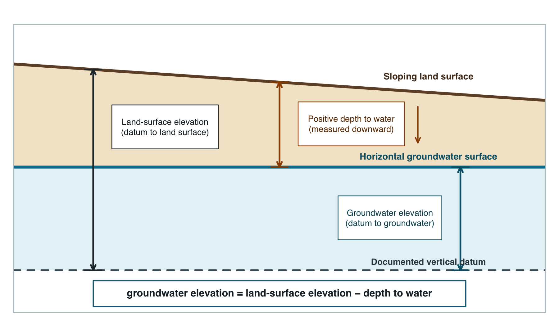
Positive depth to water plus a DEM
ps_potentiometric_points() applies:
Positive depth means below land surface. A negative value describes head above land surface, but users should verify that convention in the source record.
data("synthetic_dem", package = "potentiomap")
from_dem <- ps_potentiometric_points(
  synthetic_wells,
  x = "x", y = "y",
  depth_col = "depth_to_water",
  surface = synthetic_dem,
  name_col = "well_id",
  crs = "EPSG:26916"
)
head(values(from_dem)[, c("Name", "surface_elevation", "depth_to_water", "Z")])
#>    Name surface_elevation depth_to_water        Z
#> 1 MW-01          185.1218          18.48 166.6418
#> 2 MW-02          183.8870          18.39 165.4970
#> 3 MW-03          190.4548          18.97 171.4848
#> 4 MW-04          184.3021          18.66 165.6421
#> 5 MW-05          188.9872          20.02 168.9672
#> 6 MW-06          188.4655          18.87 169.5955
The raster and wells must represent compatible horizontal coordinates. Surface elevation and depth to water must use the same vertical units.
Depth to water plus an elevation column
from_column <- ps_potentiometric_points(
  synthetic_wells,
  x = "x", y = "y",
  depth_col = "depth_to_water",
  surface_col = "surface_elevation",
  name_col = "well_id",
  crs = "EPSG:26916"
)
head(values(from_column)[, c("Name", "surface_elevation", "depth_to_water", "Z")])
#>    Name surface_elevation depth_to_water      Z
#> 1 MW-01            185.13          18.48 166.65
#> 2 MW-02            183.89          18.39 165.50
#> 3 MW-03            190.43          18.97 171.46
#> 4 MW-04            184.35          18.66 165.69
#> 5 MW-05            189.02          20.02 169.00
#> 6 MW-06            188.40          18.87 169.53
Depth to water plus separate surface-elevation points
Separate surface observations are matched by name when possible; otherwise the released function interpolates surface elevation to the depth points with IDW.
data("synthetic_surface_points", package = "potentiomap")
from_separate <- ps_potentiometric_points(
  synthetic_wells,
  x = "x", y = "y",
  depth_col = "depth_to_water",
  surface = synthetic_surface_points,
  surface_col = "surface_elevation",
  name_col = "well_id",
  surface_name_col = "point_id",
  crs = "EPSG:26916",
  idw_power = 2
)
head(values(from_separate)[, c("Name", "surface_elevation", "depth_to_water", "Z")])
#>    Name surface_elevation depth_to_water      Z
#> 1 MW-01            185.13          18.48 166.65
#> 2 MW-02            183.89          18.39 165.50
#> 3 MW-03            190.43          18.97 171.46
#> 4 MW-04            184.35          18.66 165.69
#> 5 MW-05            189.02          20.02 169.00
#> 6 MW-06            188.40          18.87 169.53
This pathway adds a surface-interpolation assumption. Record the source-point network and do not treat the calculated elevation as more precise than its inputs.
Data frame, sf, and terra inputs
wells_sf <- sf::st_as_sf(synthetic_wells, coords = c("x", "y"), crs = 26916)
from_sf <- ps_make_points(
  wells_sf,
  value = "gw_elevation",
  name_col = "well_id"
)
c(class = class(from_sf)[1], crs = crs(from_sf, proj = TRUE), rows = nrow(from_sf))
#>                                               class
#>                                        "SpatVector"
#>                                                 crs
#> "+proj=utm +zone=16 +datum=NAD83 +units=m +no_defs"
#>                                                rows
#>                                                "32"
wells_vect <- vect(synthetic_wells, geom = c("x", "y"), crs = "EPSG:26916")
from_terra <- ps_make_points(
  wells_vect,
  value = "gw_elevation",
  name_col = "well_id"
)
head(values(from_terra)[, c("Name", "Z")])
#>    Name      Z
#> 1 MW-01 166.65
#> 2 MW-02 165.50
#> 3 MW-03 171.45
#> 4 MW-04 165.70
#> 5 MW-05 169.00
#> 6 MW-06 169.53
data.frame(
  pathway = c("direct head", "depth + DEM", "depth + column", "depth + separate points", "sf", "terra"),
  observations = c(nrow(direct), nrow(from_dem), nrow(from_column), nrow(from_separate), nrow(from_sf), nrow(from_terra)),
  finite_Z = c(sum(is.finite(values(direct)$Z)), sum(is.finite(values(from_dem)$Z)),
               sum(is.finite(values(from_column)$Z)), sum(is.finite(values(from_separate)$Z)),
               sum(is.finite(values(from_sf)$Z)), sum(is.finite(values(from_terra)$Z)) )
)
#>                   pathway observations finite_Z
#> 1             direct head           32       32
#> 2             depth + DEM           32       32
#> 3          depth + column           32       32
#> 4 depth + separate points           32       32
#> 5                      sf           32       32
#> 6                   terra           32       32
Assigning a CRS declares what coordinates already mean; transforming a CRS recalculates coordinates. See input formats and coordinate systems before interpolating field observations.